 The Chafford Gorges Nature Park has
been created in three disused chalk pits that
were actively worked until the 1950s. Lakes in
the base of the quarries have been retained,
the surrounding ground has been sympathetically
managed to encourage wildlife (both flora and
fauna) and paths have been provided for the
public to gain safe access.
The Chafford Gorges Nature Park has
been created in three disused chalk pits that
were actively worked until the 1950s. Lakes in
the base of the quarries have been retained,
the surrounding ground has been sympathetically
managed to encourage wildlife (both flora and
fauna) and paths have been provided for the
public to gain safe access.
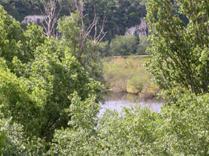
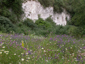
A spacious new visitor centre, with a shop
selling books, gifts, hot and cold drinks,
sandwiches and snacks, was opened in the spring
of 2006. The visitor centre overlooks Warren
Gorge, the largest of the three gorges. A part
of the panoramic view from the visitor centre
is shown in the picture on the left.
At 10.30 am on Saturday 28th June seven members
met at the visitor's centre for a geological
walk led by Diana Clements. The aim was to look
at, and discuss, the local geology.
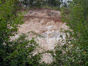
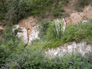
Leaving the visitor centre we walked down
Merlin Close. On the right hand side there
should have been a good view of our first chalk
face. Unfortunately the area is fenced and
trees, planted by the wildlife trust to protect
the site, have grown so high that only limited
views of the geology are now possible.
Nevertheless, we did see small solution pipes
and flint beds. One of the limited views is
shown in the picture on the right.
From Merlin Close we proceeded to Devonshire
Road where the Wouldham Cliffs gave us an
excellent view of the local chalk. Clearly
visible was a thin continuous band of flints
that can be see half way up the chalk face in
the picture below left.
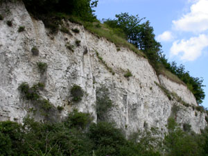 This is the Whittaker's 3 inch Flint
Band that can also be seen in chalk cliffs at
the Kent coast. The band identifies the chalk
as Seaford Chalk of the Santonian Stage of the
Upper Cretaceous dating from about 85 million
years ago (Ma)
This is the Whittaker's 3 inch Flint
Band that can also be seen in chalk cliffs at
the Kent coast. The band identifies the chalk
as Seaford Chalk of the Santonian Stage of the
Upper Cretaceous dating from about 85 million
years ago (Ma)
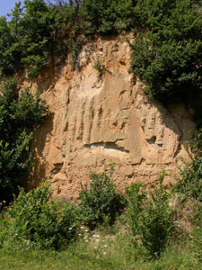
The entrance to Lion Gorge, being cut through a
chalk dividing wall, gave us an opportunity to
get close to the chalk and examine it. It was
white, very soft and frangible with scattered
flints; characteristics of the Upper Chalk.
A short walk through Lion Gorge brought us to
Philip Sydney Road where a view point enabled
us to look down the gorge that is now a
geological Site of Scientific Interest (SSSI).
Here the chalk has been replaced by Terrace
Gravels (Taplow Gravel) from former levels of
the River Thames. A small exposure of gravel
can be seen down the left-hand side of the
gorge. Though one may enter the gorge, it is
excessively overgrown and we were content to
enjoy the fine view south towards the Thames
and North Downs. The narrow gorge is the site
of a tramway that carried chalk from the pits
to barges on the river.
The site was declared a SSSI because of the
many mammalian remains it has yielded and for
the evidence of Humans (Levallois artefacts).
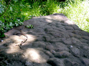
From the Philip Sydney Road viewpoint we
returned to the visitor centre, via the steep
ramp, for a lunch break. The steep ramp gave us
a close-up view of solution pipes as seen in
the picture at the bottom of this page.
After lunch we visited the Sandmartin Cliffs in
Devonshire Road. This site is kept locked
because of the need to avoid disturbance to
sandmartins that are summer visitors. Diana had
managed to obtain a key, but this is not
possible when the sandmartins are in residence!
One's first impression is the smooth vertical
nature of the face, see picture right.
Do not attempt to climb the
exposure and under no circumstances may hammers
or trowels be used on the sand face.
Those of you who are experts at building
sandcastles will know that sand size and water
content are the critical issues, and so it is
here. Examination of samples from the base of
the sand face showed that the sand particles
were extremely fine.
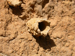
Close up, one could see some interesting
burrows in which tubes, of lattice structure,
projected from the sand face (see picture at
the foot of this page). In the same area we saw
several wasps, thought to be Chrisis
ruddii, a ruby tailed wasp. But whether
these built the burrow, were merely
investigating it or, more likely, were
predators of the inhabitants was not clear.
To learn more about these wasps click
here
During our tour we saw evidence of
cryoturbation, the disturbance of strata by
freezing. During the last ice age the chalk was
frozen to a great depth (permafrost). In the
brief, warmer summers the upper metre or so of
the chalk thawed and the chalk contracted.
Repeated cycles of freezing, expansion, thawing
and contraction caused the chalk to crumble and
form a semi-liquid consistency that has been
described as 'like porridge'. The denser,
overlying Thanet Sand sank into the chalk
causing the less dense chalk to rise up around
the descending sand, producing the disturbance
that we see today.
Deposits of reconstituted chalk, formed by
periglacial action during the Pleistocene
period, are known as 'Coombe Deposits'. When
these are combined with lumps of chalk and
cemented into a hard mass, the product is known
as 'Coombe Rock'.
 Our final visit of the day was to see a
number of Sarsens at a spot above the lake in
Grays Gorge (see picture left).
Our final visit of the day was to see a
number of Sarsens at a spot above the lake in
Grays Gorge (see picture left).
Sarsens are formed at the saturated bottom of
sand deposits. It has been suggested that
siliceous material in solution percolates down
through the sand and crystalises out in the
lower layers to bond the sand grains into a
hard quartzite-like rock (technically an
orthoquartzite). The question was "How did they
finish up here?"
It was generally agreed that the rocks must
have formed at the base of the Thanet Sand.
Inspite of being excellent building stone, the
rocks were probably not wanted by the quarrymen
who were excavating sand and were therefore
cast aside in an unused part of the quarry.
If the weather is fine, one can easily spend a
day in this nature park, studying the geology
and wildlife.
It is recommended that anyone wishing to do so
obtain copies of the following documentation:-
-
British Geological Survey, England and Wales
Sheet 271, Dartford, 1:50,000 Series.
-
British Geological Survey, Memoir for the
London Area, Sheets E256-7, E270, E271, 2004.
-
'Your Guide to Chafford Gorges Nature Park',
Published by the Essex Wildlife Trust
This colourful guide contains detailed
descriptions of the park, its origins and
wildlife and is available, free of charge,
from the park Visitor Centre.
This was not a 'lecture tour' but more in the
nature of a 'Socratic dialogue'. During our
rambles, geological features were observed
which the members discussed and tried to
explain. Sometimes we agreed, other times we
agreed to differ. The weather was fine, the
going was mostly easy and a thoroughly
enjoyable time was had by all.
We wish to thank Diana Clements for
organising and leading the walk; for
encouraging discussions during the day and for
her expert knowledge of the area and its
geology.
Some pictures of the Chafford Gorges Nature
Park, taken by Stephen Taylor, are shown
below:-
|
|
The profusion of wild flowers at the base
of the chalk cliffs in Devonshire
Road.
|
A wonderfully close view of solution
pipes at Lion Gorge, seen from the steep
path
|

|
|
A Skipper butterfly on the reserve. Black
antenna tips suggest that this is the
Essex variety Thymelicus
lineola.
|
An unusual burrow protruding from the
face of the Sandmartin's Cliff.
|
Access and Safety
From junction 30 of the M25, take the A13
eastwards and leave at the second exit (A1012
southwards). Follow directions to Grays and
Chafford Hundred. Cross the first roundabout,
taking the fourth exit into Elizabeth Road. At
the second roundabout turn right into
Devonshire Road and almost immediately turn
right into Drake road. Follow Drake road as it
bears round to the left, crossing several mimi
roundabouts. After about 1.5 Km the road turns
sharply left and the signboard marking the
entrance to the Chafford Gorges Nature Park and
Visitor Centre will be seen on the right.
The nature reserve has been developed from the
site of three former chalk quarries, and is now
the centre of a large modern housing
development. The park is intended to be a
nature reserve open to the public as a local
leisure facility. However, some sensitive areas
are locked and access is only possible by
permission of the Essex Wildlife Trust.
Note: Local traffic can present a hazard
when walking on, or crossing roads between the
gorges. Young people should be carefully
supervised at all times. Additionally, paths in
the former quarries can be uneven and chalk,
when wet, is very slippery.
Do not hammer, or attempt to
climb, any of the chalk or sand faces.